Hurricane Lowell Swings North Toward Kauai Under Storm Warnings
Major Hurricane Lowell swings north, triggering hurricane watches and tropical storm warnings for Kauai County as Hawaii braces for severe weather.
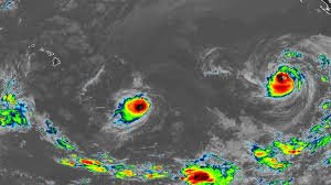
Residents across Hawaii are racing against the clock. Hurricane Lowell has executed a sharp turn toward the north, steering the Category 3 monster directly toward the western edges of the island chain. Kauai and Niihau now face a double threat as emergency management agencies issue urgent warnings.
The storm’s current track is a nightmare scenario for local officials. It’s expected to pass just west of Kauai County late Monday into early Tuesday morning. A slight eastward nudge in the official track has dramatically raised the stakes for Niihau and Kauai, increasing the likelihood of direct hits from hurricane-force gusts.
A Looming Threat on the Western Horizon
As of late Sunday, Lowell was packing maximum sustained winds of 115 miles per hour. It remains a powerful Category 3 storm. The center of the hurricane sat roughly 445 miles southwest of Lihue, or 480 miles southwest of Honolulu. It’s chugging north-northeast at 10 miles per hour, a slow but steady march that gives residents little time to dally.
The storm’s reach is massive. Hurricane-force winds extend outward up to 60 miles from its center. Tropical storm-force winds reach much farther, stretching up to 175 miles. This means even a near-miss will lash the islands with destructive, high-velocity wind bands.
Meteorologists expect Lowell’s wind field to expand on its eastern side. This growth, combined with the eastward shift in the storm’s track, means the risk of severe damage has spiked. Kauai County is currently under a tropical storm warning and a hurricane watch. Additionally, a hurricane warning has been hoisted for the Papahanaumokuakea Marine National Monument, signaling danger for the remote northwest Hawaiian islands.
The Science Behind the Storm’s Path
Atmospheric steering currents are driving this sudden northerly turn. A strong south-southwesterly wind shear is expected to slam into the hurricane by Monday night. While this high-altitude wind shear should start tearing the storm apart, it won’t happen fast enough to spare Hawaii.
Forecasters warn that Lowell will still be a fully formed hurricane when it makes its closest approach on Monday night. ‘We can’t rely on wind shear to save us here,’ said one local meteorologist. ‘The storm is simply too large and moving too fast for immediate decay.’
By Tuesday night, Lowell is projected to pivot north-northwest and slow down. But before that happens, the islands must endure a gauntlet of wind, rain, and rising seas.
Orographic Winds and Mountain Dangers
Hawaii’s unique topography poses a distinct danger during tropical events. Wind speeds atop ridges and along the windward and leeward sides of mountains can be up to 30 percent stronger than at sea level. In some highly elevated spots, the acceleration is even more extreme.
This atmospheric squeeze play means upland properties and mountain roads face localized winds far exceeding the storm’s baseline measurements. Power lines on high ridges are especially vulnerable. Utilities are already warning customers to prepare for prolonged blackouts if major transmission lines go down.
Torrential Rains, Mudslides, and Flash Floods
While the wind is terrifying, water is often the real killer in Hawaiian hurricanes. A statewide flood watch is active through Tuesday afternoon. Lowell is dragging a massive corridor of tropical moisture along its eastern side, setting the stage for historical downpours.
Kauai is expected to see the heaviest rainfall. Forecasters predict widespread totals of 6 to 10 inches, with isolated areas buried under up to 14 inches of water. On the Big Island, 4 to 8 inches are expected, with some mountainous spots seeing up to 12 inches. Maui is bracing for 2 to 4 inches, with localized peaks of 8 inches, while the remaining islands can expect general totals of 2 to 4 inches.
This volume of water will likely trigger dangerous flash floods and mudslides. Hawaii’s volcanic soil can only absorb so much water before it liquefies and slides down steep hillsides. Roads could be washed out, cutting off remote communities on Kauai’s north shore and parts of the Big Island.
Tornadoes and Storm Surge Risks
The storm’s outer bands are also bringing a rare threat to the islands: tornadoes. Meteorologists warn that several tornadoes are possible near Kauai and Niihau from Monday afternoon through Monday night. A few isolated tornadoes could also spin up across the rest of the Hawaiian islands, caught in the storm’s rotating outer arms.
Along the coast, the situation is equally grim. The combination of storm surge and high tide will force ocean water onto normally dry land. Coastal flooding is expected to be deepest near and to the right of the hurricane’s eye, where onshore winds will push massive waves inland.
Swells from Lowell will create life-threatening surf and deadly rip currents across the entire island chain for several days. High surf warnings are already in place for south-facing shores through Tuesday morning. Meanwhile, the west shore of the Big Island is expecting waves to climb from 6 to 8 feet on Monday morning to a crushing 12 to 16 feet by the evening. East-facing shores of Oahu, Molokai, Maui, and the Big Island are under high surf advisories for waves up to 10 feet.
Emergency Services on High Alert
The Hawaii Emergency Management Agency (HI-EMA) has activated its emergency operations center to coordinate state and federal resources. Governor’s office representatives confirmed they are in constant communication with the White House and FEMA administrators. Emergency shelters on Kauai are being prepared for immediate opening if coastal evacuations become necessary.
The U.S. Coast Guard has also begun securing ports across the state, warning commercial vessel operators to seek safe harbor. ‘We are urging mariners to take this storm seriously,’ a Coast Guard spokesperson said. ‘Once the storm hits, rescue operations become incredibly hazardous, if not impossible.’
Emergency officials are reminding residents that emergency services may not be able to respond during the peak of the storm when wind speeds make it unsafe for first responders to be on the road.
Supply Chains and Economic Impacts
State officials are watching Honolulu Harbor closely. Hawaii relies on marine shipping for nearly 90 percent of its food, fuel, and consumer goods. A prolonged port closure could lead to empty grocery shelves and fuel shortages within days.
Retailers across Oahu and Kauai reported long lines over the weekend as residents stocked up on bottled water, batteries, and canned goods. ‘The shelves are emptying out fast,’ said one shopper in Lihue. ‘People still remember Hurricane Iniki, and nobody wants to be caught flat-footed.’
The tourism sector is also bracing for disruptions. Flight cancellations are expected to rise as high winds hit the islands’ airports on Monday afternoon. Hotel operators are advising guests to stay indoors and keep away from beaches.
A Quiet End for Karina
While Lowell commands attention, another system is quietly bowing out. Karina has rapidly weakened and is now a post-tropical cyclone northeast of the state. It poses no threat to land.
Weather officials expect Karina’s remnants to completely dissipate within the next 48 hours. It’s a small mercy in an otherwise highly active and dangerous hurricane season.
State officials stress that now is the time to finalize emergency kits and family plans. Waiting until the wind starts howling is a recipe for disaster. Preparing for the worst is the word from the county emergency operations center as the outer bands of Lowell begin to cloud Hawaii’s southern horizon.